An absolute bucket list hike, considering Saddleback is the highest peak in Orange County and the constant view of the towering giant teases you daily to come straddle the saddle! Our hike organizer, Anastasia, picked this hike as a precursor hike to Havasupai that is scheduled for May. Figuring if we could manage this hike, the 10 mile hike into Havasupai campground would be a piece of cake. So Anatastia was able to entice 5 of us TBs, since these aren’t my normal TBs, for the sake of this post TB will be short for trail babes, Karyn, Karen, Diana, and Sabrina!! We left Karyn’s house at 6:30 am and arrived at the trailhead around 8 am. Same drive as the West Horsethief hike without the last jarring mile of road. Upon arriving at the Holy Jim parking, I was glad we did this hike on a Tuesday, there was only one or two other cars in the parking lot. The last time we passed it on the weekend, early morning, it was packed to the rim with cars. After using the dirty porta potties we were off at 8:15 am. Clear skies, crisp cool air, no crowds, makes for a great start!

Trailhead – Trash cans neat and not overflowing 🙂

Sabrina, Karen, Diana, Anastaia, Karyn

Heading up through the valley to Holy Jim Trailhead

I love signs, can you tell?

Spotted at a house, pretty cool…help yourself to water with a tip coffee can. Humanity at its finest! (or is that capitalism?)

Creek crossing

Love the spookiness in the morning light

Choices are good, they determine our destiny…
About 1/4 mile, after crossing the creek, you will come to a junction that leads you to Holy Jim Falls, we veered right on this path. A beautiful short trek to the falls, which rewarded us with actual falling water, a precious commodity during this drought California is going through.

Is it a selfie if you don’t hold the camera?

The falls without the natural beauties, ie TBs!
After this short diversion into paradise, we needed to focus on the task at hand about 3,700 ft up and 6.5 miles to go. Sigh, let the whine begin, but it sure beats sitting in the office all day… The trail was beautifully colored green and punctuated with wild flowers along the way. The views grew more spectacular the higher you crawled, I mean climbed.
It was about 1 mile or 1.5 miles past the waterfall, we lost some trail babes, Karyn and Sabrina. They had more pressing matters than to summit Saddleback so they needed to turn around and head back to the chaos of Orange County.

Sabrina checking out the view before heading home

Yes we are still in Orange County, Toto

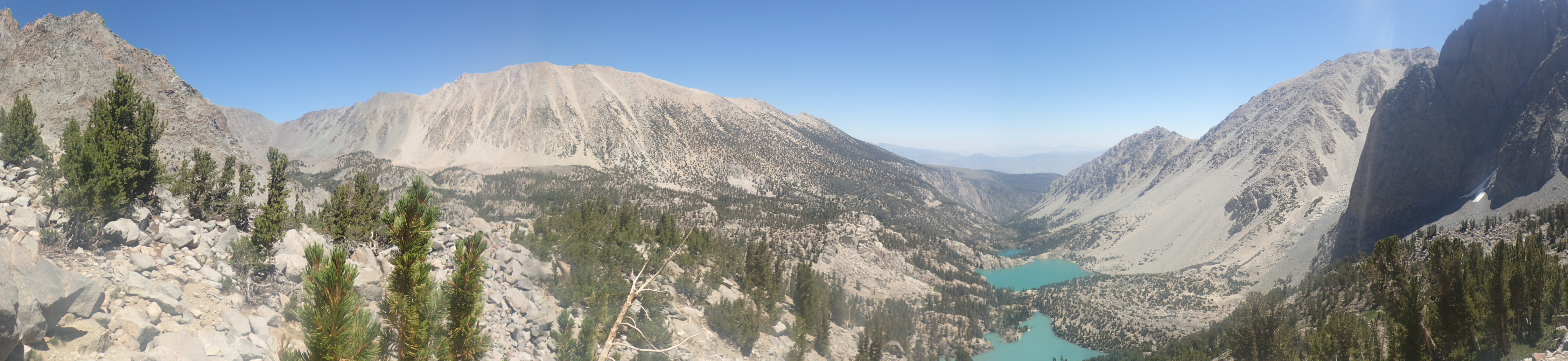
Trekking up and up, please note the BLUE sky…

See the heart rocks in the green

Where is Karen? If I could figure out how to upload high resolution pictures, you could find her!
We continued along Holy Jim Trail until we got to the Main Divide Road, this was approximately 5 miles according to my Walkmeter GPS. Here we chose to go right, to head to the Upper Holy Jim Trail. You could choose to go left and follow the road, but where is the fun in that? So we paused for a small break and continued a short way on the road to find the upper trailhead.

Almost to the Main Divide Road

Local hikes are never complete without prerequisite grafitti

Another sign…
Found the Upper Holy Jim Trailhead sign, however not sure where the trail is? Let’s check through these bushes. This is definitely not a well maintained trail, with its loose rocks, steep steps up; it was more like a water way for heavy rains. But we forged on, not going to let this trail get the best of us. We did not see Karen very much! She is a super stud hiker, one step for every 5 of mine. She was the leader of the pack, I tried to keep up with her on this trail, no chance. So I was sandwiched between my scout, Karen, in front and my loquacious trail babes, Anastasia and Diana, behind me. Now while I don’t mind hiking by myself with nature and the voices in my head, I do like to know how the others in my party are doing. So I would assume Karen is alright as she is above me. But how to keep an eye on the trail babes behind me? So problem solved when I found myself stopping to gasp for air, trying to catch Karen, I would wait long enough to hear Anatasia and Diana coming along. Perfect. Let’s move on up this nightmare of a trail.

San Jacinto in the background, it is, trust me.

My spooky tree find on the nightmare trail
We all made it to the top of the Upper Holy Jim (would not be my name for it) Trail. It ended at the Main Divide road, where we had another 800 ft up and 1.6 miles to go. This was slightly boring to me, as I am not a road hiking fan, but we pushed it to the top. Remember the blue skies in one of the prior pictures? Well the blue skies didn’t exist when we summited, we were in the middle of a thick, cold, cloud. Now the top is a disappointing mess, littered with every communication equipment you can imagine, making you search for the actual peak, which is to the right when you get to the top. I probably would have overlooked the mess of equipment if I could have gazed upon the amazing view of the great Orange County below me, but not today, so I get to whine. After a quick lunch break, we headed back down, this time taking the Main Divide Road to the Holy Jim Trailhead.

Yes a selfie! At the top, in the fog, with a HG Wells Martian…

Signed our names on the paper in the tin can…

Heading down, notice how the skies seem to be clearing

So disappointed in the lack of view, almost forgot to take a photo of the disarray of equipment at the top, here is a small sampling.

Headed back to Holy Jim NOT Upper Holy Jim. Notice how UHJ isn’t even on the sign…maybe that is a sign.
We fell into our trail line and made our way down the road, pretty uneventful, so I will take this space to show you the beautiful flowers the winter rains brought us.

OLYMPUS DIGITAL CAMERA

OLYMPUS DIGITAL CAMERA

OLYMPUS DIGITAL CAMERA

OLYMPUS DIGITAL CAMERA

OLYMPUS DIGITAL CAMERA

OLYMPUS DIGITAL CAMERA

OLYMPUS DIGITAL CAMERA

OLYMPUS DIGITAL CAMERA
If I knew the names of the flowers, I would share them with you, but since that is not the case, I will let Olympus have the space for advertising. I apologize for the weird spacing of the photos, if I had time to become a WordPress expert, I would fix it. But more mountians are calling, so a mediocre editing job is what you get. The coolest thing I encountered on our hike is this plant:

Cuscuta Salina

AKA Salt Marsh Dodder
After some internet research, I was able to find the name for this deeply colorful netting of a plant, Cuscuta Salina, aka Salt Marsh Dodder. A parasitic plant stealing its required nutrients from the surrounding plants. So while it is quite intriguing to look at, hopefully it does not spread throughout the valleys.

Back at the Holy Jim trail

Beautiful flower landscape

Picture of Anastasia and Diana…somewhere.

Pretty trail photo, with clearing skies in the background

I felt like I was following a flower girl dropping petals, because the whole way down these yellow petals lead the way.

Waited for Anatasia and Diana at the river crossing.
We emerged at the parking lot around 5 pm. Karen was napping on a picnic table, soaking in the sun, that was not there at the summit; there was not a cloud in the sky, when we finished. Sigh! We all survived the ascent and descent, now knowing we are ready for Havasupai! (Ha Ha little did we know, but that is another blog entry). According to my walkmeter, we hiked around 17.7 miles (I wander a lot), hike time was 8:51 hours, with 6 hours of actual hiking, not stopping to gasp for air. Total ascent 4,689! Thank you Anatasia for picking this winner as our training hike, other than the lack of views, it rocked! We were home around 6:30 pm where my lovely family was waiting for me with pizza in the oven! Yum! Again another hike ending without wine, hopefully this isn’t the trend…
Stats: 44,704 steps, 480 flights of stairs, 2 liters of water – A cloudy day is no match for a sunny disposition. – William Arthur Ward
So – Fantastic!!! and funny and wish I had been there (or would I) – Wicked one, would that have been a do for me – knowing the height thing!!? Love you and your stuff! Rock and Walk on!
Ha! You could have done this one! However not the Mt Baldy one, just wait for those pictures!!