Some of the best hikes are ones you have driven by for 30 plus years and never have stopped or have known you should stop. I googled waterfalls in LA and Modern Hiker suggested Placerita Canyon Firebreak Trail. This trail head is located in the Placerita Canyon Natural Area and Nature Center on Placerita Canyon Road off of the CA-14. Shana and Joanne (newbie TB) decided to join me on this excursion with an early morning lift off at 6:30 am from my house. Sunday, 6:30 am … sucks!!

Found the start
One would think Sunday early morning would be a breeze on the freeway, but no, some smart ass decided to shut down a freeway interchange on the 5. So we had to cruise around in the ghetto to get ourselves rerouted out of LA.

Very empty park this early in the morning

Gazelle without her leash
We arrived at the Center to a fairly empty parking lot and after using the almost full shitters (outhouse is just too kind of a word), we headed out looking for the Hillside Trail at 7:54 am.
Going up this trail just a little ways brought us to Excalibur’s sword, or one that looks like it, so Shana had to try…look how strong she is:

Looks tempting

Can she do it?

Must have used her good thumb for this feat

A couple of stairs up to the water tower
A short scramble up, we came to a fork, one path went up to a water tank and one went down into the canyon. We sent our scout gazelle up to the tank to check it out, she galloped up the stairs and around the tank, which brought her to the conclusion this wasn’t the right path. So we headed down the other path for a bit, until my inner direction compass bitch suggested this path isn’t right. I whip out the detailed directions printed from Modern Hiker (10 pages), which tells us the Manzanita Mountain Trail can be found behind the water tank. Up the stair path we went, Joanne and I, for the first time, and the second time for Shana, she needs those extra steps to keep up with us on step count! Low and behold there was a path behind the tank, a little washed out and overgrown looking, but it was a path.

Our first view

On the right path

Trail saving stairs, gotta love them!
This was a nice slightly inclined path that brought us to the firebreak road.

Shana moving ahead

Everything is SO green, so uncalifornian.

See Shana waving above us?
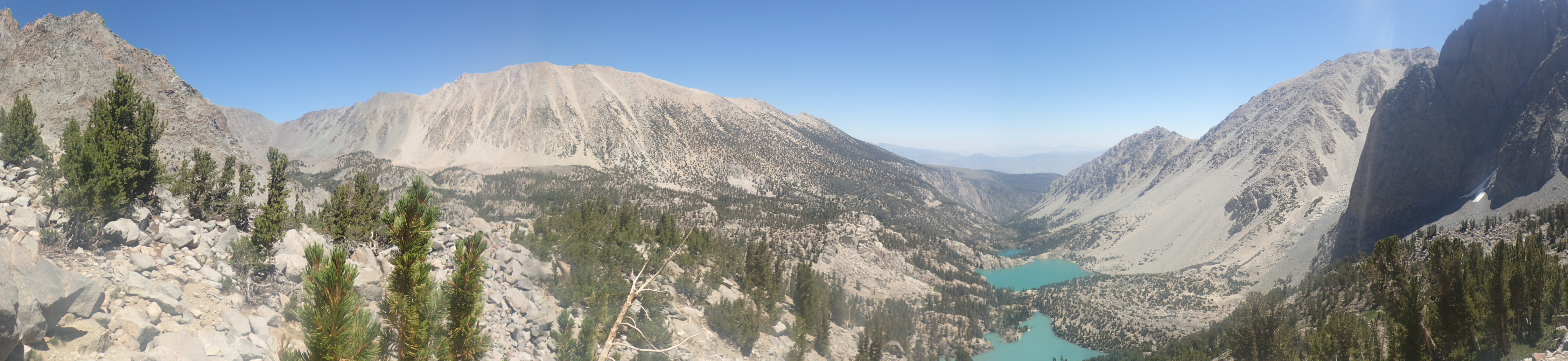
Here we admired the view, marveling how high we were in such a short time.

A close up

See the double diamond road ahead of us
Gazelle ventured a little further up a hill on our right and took our picture. Now at some point on the trail prior to getting to the firebreak, a couple passed us going the other way, and said “Good job ladies”. I didn’t think much about that statement until we started heading up the firebreak. The first part looked a little hairy and towards the top of this first hill we could stand straight up, lean slightly in towards the hill and actually touch the hill with our hand, kind of like skiing on a double black diamond at Mammoth. Add in the mix of rocky soil and we were an accident waiting to happen. So imagine our excitement when we made it to that top without an incident; that excitement bubble burst when we looked at the trail ahead and saw another black diamond hill ahead, and another, and another…

Quite a ways away from the water tower…

Still going up….
On one of these hills some dreaded bikers were flying down on us like the two dollar kids from the movie, Better Off Dead, one of whom completely lost control and was sliding towards me. I had nowhere safely and quickly to scramble to, but somehow avoided contact with him. Luckily he missed Joanne too, who was behind me. I am pretty sure if he hit me, we would have taken her out too.

Looks tame in the valleys

That is Magic Mountain…

This has to be the last one…

Finally a trail that led us around the mountain. Can see the top…

One more hill, with a change in dirt.
But we all made it safely up this double black diamond and the next one and the next one and the next one… 1,644 ft of elevation total in about 2.8 miles and 2 hours and 15 minutes. I know, we averaged about 1.4 miles per minute, “Good job Ladies”!!!

Almost to Wilson Saddle
We made it to Whitney Canyon Road, where there is a huge tree that you can see when you drive by on the CA-14. I check it out now every time I pass it, a personal trophy. My son says it looks like a bush from the freeway. We rested here, snacked, watered, and took pictures, then continued on.

Panorama view with a photo bomb

Here is where I need to read more before hiking. Had we hiked a couple hundred yards further, we could have rested on these nice benches, with a view of the southland.

Wave to Bodin at Guide Dogs of America

Pretty flowers

Would have been a great snacking table
Oh well! A biker offered to take our picture and asked were we had come from, we told him the firebreak road on the left, and he said, “Ohhh the Viper”, hence the name of the blog. The nickname Viper was a much better description of the venomous firebreak road.
We were all done with the up portion of the hike and found the Los Pinetos Trail to head down.

Waiting for the faster descendants to go first

Los Pinetos Trail head
The biker clan was headed down this trail as well, so we waited until they went and then began our descent. Let me just start with, I didn’t know this area off of the CA-14 was this beautiful. Check out the photos (BTW sorry for the finger smudge, I didn’t notice it until I got home):

Complete change of scenery, gotta love rain!

Rain makes everything beautiful

Did I mention this path went down for us…

Lots of cool trees…

and a couple of view spots.
This was a fairly easy descent, with some rutted-up, washed-out parts that needed care in walking on. But for the most part, it was shaded, with a few openings in the trees for some quick views. Oh, and yes, according to Joanne, filled with poison oak, she is a magnet for the poison oak, so she was very careful where she walked. We emerged from the Los Pinetos Trail on to the Canyon Trail at about 10:30 am, so it took us almost an hour to go about 2.3 miles.

Well marked signs.
We needed more distance, so we added the Waterfall Trail to our hike, a path that is about 1.2 miles. There were definitely more people at this lower elevation, as I think, besides the biker clans, we only saw about 8 other hikers in the higher elevations.
The waterfall could have definitely used a little more water, but we were happy with the little trickle we found, us southern Californians are so easy to please.

Caution STAY ON TRAIL

Probably because of the Poison Oak? Guess whose finger?

Had to wait here, as there was a little traffic.

Can you spot the person?

It was a fun path

See I told you! Totally worth it!

Camera moment Joanne SMILING while standing next to PO

Ooooh Shana and I venturing past the DO NOT PASS sign
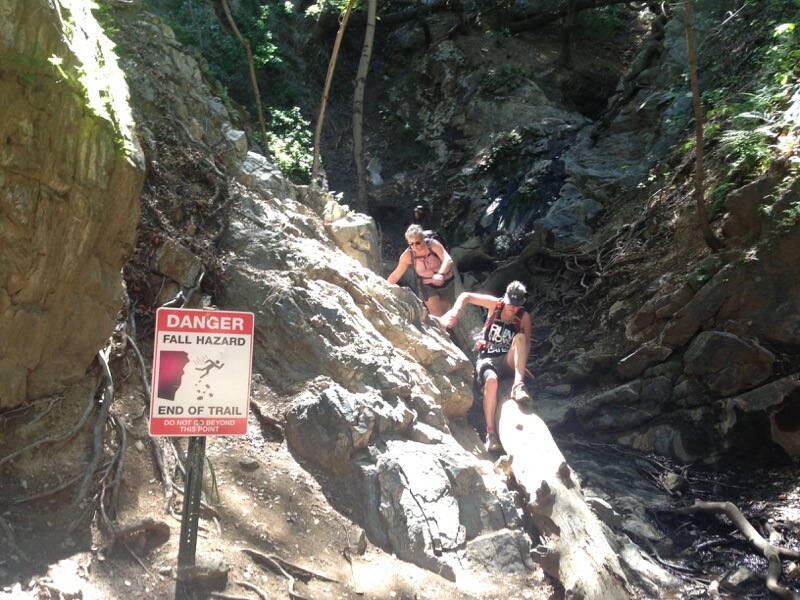
We made it out safely!

OLYMPUS DIGITAL CAMERA
We went back to the Canyon Trail and found a table at Walker Ranch to have a nice lunch with a couple of flies, until we lathered on the Amber Bromance! (Thanks Steph). Bye bye flies!
Around noon, we headed to the left on the Canyon Trail towards the Nature Center to complete our loop. Along this path we were passing numbered markers, at first we thought they were labeling campsites, but when some numbers obviously were not campsites, we figured out it was a guided tour. You can get a trail guide at the center, just FYI.

Canyon Trail – easy level path along the stream

Shady too

Used to be a working ranch

Had to use the Dramatic setting on the camera…
Now this trail is crowded with runners, walkers, strollers, and at some points hard to keep pace, but we finished at 12:30, about 9 miles round trip. Since the nature center was open, we stopped in to check it out. Bathrooms rocked!! Flush toilets…

Trail sign, lots of easy venturing trails…

Live rattlesnakes, ooohhh…

This was cool, a live working see through bee hive.
Now the fun starts, getting home! Somehow trying to avoid traffic, we ended up on the 10 fwy heading to the 710 fwy. Well the smart ass that shut down the 5 earlier this morning, decided to shut down the on ramp to the 710 from the 10, so this put us on N. Eastern Avenue and Caesar Chavez Avenue. I have obviously forgotten to check the “avoid suspect areas” in my Waze app. So we had another off freeway tour of LA, which brought us by the Home of Peace Memorial Center. Let me just say, as interesting as it looked, it was not somewhere I wanted to be after dark, spooky cemetery. We came home to a warm jacuzzi and a home cooked meal and of course a great bottle of wine.

Stats: 22,624 steps; 222 flights of stairs; 1 thumb tendon (injured prior) but was diagnosed as a medical emergency on this hike; a couple of bottles of wine – “Leave nothing but footprints, take nothing but pictures, kill nothing but time – John Kay”
You are so not allowed to take the WSM on this hike! Great pics!
Thanks! I like the acronym!
Fun day. Glad I was “finally” able to join a hike!
I know!! Finally!! Many more to come!